Samafal Posted August 29, 2013 Jubaland and Its Inhabitant By F. ELLIOTT, A.S.P. The Geographical Journal, Vol. 41, No. 6 pp. 554-561 June 1913 The north-western boundary of Jubaland is a line drawn from the Lorian swamp, passing through the districts of Wajheir and Eil Wak, and terminating at Dolo, on the river Juba. Its south-eastern boundary is the Indian ocean. Its eastern boundary is the river Juba, whose eastern bank is within the Italian sphere of influence. The western boundary is an imaginary line from the Lorian swamp to the Bajun settlement of Kiunga on the coast. Off the coast is a series of coral reefs and small islands, partly inhabited, which makes the approach by vessels somewhat difficult. The available harbours are two in number, Kismayu and Port Durnford; the latter can only be entered by vessels of light draught. The mouth of the river Juba is blocked by a sand-bar, which can be crossed by vessels not requiring more than 6 feet of water. There is, in addition, the large creek of Arnoleh [Anooleh] (place of milk), which is navigable by dhows, and extends some 20 miles inland. Along the shore there is a line of sandhills stretching inland for about a mile. Their heights average not more than 200 feet, and they are clothed with bush and mimosa thorn. Immediately behind the sandhills lies a flat country, thick with thorn and other bushes, but which possesses here and there open or park-like plains whereon cattle, camels and goats are pastured. As we proceed north-westward the belts of bush become denser and more difficult to penetrate, while in the more southern districts the open plains are larger and more numerous. The general view of the country is uninteresting from lack of hills, and depressing from want of variety; yet it possesses great possibilities as a grazing country. Along the whole of the western bank of the river Juba lies a belt of what is called " black-cotton " soil, the fertility of which, under irrigation, may be compared to that of the Nile valley. It is already producing crops of cotton equal to the best Egyptian, and in the future might become a district of considerable commercial importance. The Juba, locally called the Webbe Ganana, rises in the mountains of southern Abyssinia. Its course is southward, but it winds in many directions. Its only tributary in Jubaland is the Daua. The local drainage is very small, and there are numerous swamps on either bank. The river is lowest from December to March, it then rises slowly until May. After this month the river again falls, and this fall is followed by its greatest rise, which occurs between August and November. The banks are well defined and clothed with vegetation and bush. The swamps lie beyond these banks. The river is navigable all the year round to Yonti. During the floods steamers can even reach Serenleh. The tsetse fly haunts the banks and swamps. The Lorian swamp in the north-west corner of the country is in the rainy season for the most part a morass with a circumference of about 60 to 70 miles, but having moderately deep pools of water surrounded by reeds. In the dry season it is a mud flat with a permanent supply of water in its midst. This swamp is supplied from the slopes of the Aberdare mountains and Mount Kenya with water which enters it by the E. Uaso Nyiro river. There is a clearly defined river-bed, called the Lak Dera, connecting the Lorian swamp with the Wama lake. This river-bed is now dry, but the natives report that water has been known to flow down it as far as Afmadu (black mouth), which is a district about 30 miles from the river Juba. The general direction of the above-mentioned Lak Dera (long stream) is east until it reaches the Afmadu district, where it is joined by the Lak Jera river-bed, and this has a stream of water during the season of heavy rains. After passing Afmadu the united river-bed turns almost due south until it reaches the Deshek Wama (Wama lake), a lake which formerly had permanent water extending 16 miles in length by about 2 miles in breadth. This lake was formerly fed by a stream proceeding from the river Juba at a point about 50 miles from its mouth, and it was drained by another stream entering the Juba 20 miles from its mouth, near the town of Yonti (noisy place). The feeding stream has been lately blocked by an artificial bank, and the lake is now dry except in the rainy season. Quote Share this post Link to post Share on other sites
Samafal Posted August 29, 2013 Towards the south-west of Jubaland exists a plateau of slight elevation. From this in the rainy season a considerable amount of water flows into a series of swamps, drained by two creeks entering the sea by a common mouth at Port Durnford. These swamps are called by the general name of Wama Eidu. The climate in general is healthy even for Europeans, for although the heat is often intense,1`it is a dry heat very different to that of places to the south. The average coastal temperature is 80?, but inland it is greater. The seasons are as follows : Gu, The heavy rains (March to July). Haga`, Dry season (July to August). Dair, Lesser rains (September to November). Dira`, Dry season (December to February). The two dry seasons are sometimes also called Jilaal, and the two rainy seasons Barwaaqo. The rains fall inland first, and are often accompanied by severe thunderstorms. On the coast the rainfall is less than in the interior. The two monsoons are equally divided into periods of six months each; the south-west, blowing from April to August; and the north-east from September to March. Between the two monsoons comes a calm, when the heat is excessive. The country may be roughly divided into the following districts : Rama-adi, Bajun, Kismayu, Juba river, Afmadu, Serenleh, Eil Wak, Wajheir, Lorian. The district of Rama-adi, including the sub-district of Joreh, contains a group of flat-topped low hills on which a fairly plentiful quantity of rain usually falls during the year. This water, draining into the swamps mentioned above, causes the country to possess valuable feeding-grounds for cattle. Port Durnford is the natural harbour for this district, but at present the trade is undeveloped. Much valuable wild-vine rubber could be obtained from this neighbourhood, but the trade is hindered because the Somali, who dominate the country, are too supine to gather the rubber, and will not suffer the coast tribes, who are not Somali, to collect it. Three sub-tribes of the ****** Somali dominate the Rama-adi district, namely, the Abd Wak, the Maghaabul, and the Abdullah. They possess large herds of cattle, but they do not breed camels. The Bajun district consists of Port Durnford, the sub-district of Arnoleh [Anooleh], and a series of small islands adjacent to the coast. The natives include the Bajun, the Boni, and the Gala tribes. The Bajun are a race quite distinct from the Somali, and they have their own language and customs. Their local name is Wa-Tikuu. They obtain a living by fishing and marine trading. They claim to be descended from Persian settlers; this is corroborated by the existence in their district of ruined stone houses of distinctly Persian architecture, and also by their light complexion and regular features. The Boni tribe formerly lived in the Gurreh [Garre] country on the borders of Abyssinia, where their sole occupation was that of hunting. Gradually they spread southward until they reached that part of Jubaland then inhabited by the Gala, who are locally termed the Wurday. With this tribe they made an agreement that they should be allowed to live and hunt in the districts of Afmadu and Deshek Wama, under condition that one tusk of every elephant killed should be handed to the Gala. Jubaland Wa-gosha village When the Somali and the Gala began fighting the Boni were neutral, but when the former proved victorious the Boni retired into the thick bush, where for two years they lived on game. Subsequently they made with the ****** Somali a similar arrangement to that which they had formerly made with the Gala, and this arrangement is still carried out. They now have settlements in Arnoleh [Anooleh] and the hinterland of Port Durnford. In physique they are in no respect like negroes. Oppressed and persecuted by the young Somali, they have become extremely timid and shy of strangers. If a traveller approaches one of their villages, the whole population takes refuge in the thorn bush, where it is quite impossible to track them. Their weapons are bows with poisoned arrows. This poison they obtain from a scarce tree called Wabaiyu, which is a species of Euphorbia. Of late years this tribe has begun to collect the wild rubber around Arnoleh [Anooleh] and to barter it with the Bajun in exchange for cloth. In hunting they have remarkable skill, and their knowledge of the bush is wonderful. When water fails them in the bush they watch the birds, and when they see the birds sitting on yak trees in any numbers, their experience tells them that water will probably be found in the hollows of some of the trees. These yak trees have thick stunted trunks in which large cavities are often to be found. The branches of the trees spring from the circle of living wood round the cavities. The marriage customs of the Boni are very simple. When a young man wants a wife he goes hunting until he kills an elephant, of which the one tusk is for his Somali superior and the other he exchanges for cloth. The cloth is given to the girl`s father, and if it is sufficient in quantity she becomes his wife. In intelligence the Boni are superior to the Bajun, but not equal to the Gala or the Somali. Their language, which is at present unwritten, somewhat resembles that of the Somali, yet the difference is too great for mutual understanding. It is noteworthy that a small settlement of Boni, living on the banks of the Juba, have begun to cultivate maize. It is difficult to estimate the number of Boni now living in Jubaland, but probably they do not exceed a thousand. This interesting tribe, who may possibly be the aborigines of the country, are rapidly decreasing in numbers, and in a few years will probably be extinct or merged among the Somali, whose missionaries are busily employed in converting them from Paganism to Mohammedanism. At Arnoleh [Anooleh] is the only settlement of the Gala tribe in Jubaland, though they are to be found scattered among the Somali throughout the whole country. Monseigneur Taruin Cahaigne, of Harrur in Abyssinia, has suggested, according to Colonel Swayne, that this tribe had their original local habitation in Tanaland. It would appear more probable, from inquiries made from the Gala themselves, that their tribe came from the north of Italian Somaliland, whence they were driven by the more powerful Somali; and that they first took refuge in Jubaland and afterwards in Tanaland, where a large settlement of them still exists. Northern Somaliland can show many cairns of Gala origin, but in Jubaland I have found not one. It appears that, after being driven across the Juba by the Somali, the Gala took possession of the country to the west of that river. About 1842 the Somali crossed the Juba, attacked the Gala, and were defeated with great loss. These attacks were continued until 1845, when tbe Somali offered peace on condition that they should be allowed to inhabit Jubaland side by side with the Gala. The Gala foolishly consented to this. In 1848 the Somali treacherously broke the agreement, and drove the Gala south ward and westward. Many of them were starved into servitude under the Somali, and are now employed in considerable numbers as herdsmen in the ****** country. The Gala are mostly Pagans, but lately a considerable number of them have become converts to Mohammedanism. Their marriage customs do not include the giving of a dowry, and their conjugal morality is very lax. In intelligence they compare unfavourably with the Somali; nevertheless they are a courageous and usually self-restraining race, yet subject to violent fits of excitement when sufficiently provoked. As traders and hunters they are more skilful than a Somali, but not equal to the Boni. Kismayu, showing sandhills, in around 1913 The Kismayu district may be said to extend from the coast northward to the Deshek Wama lake, and on the east it is bounded by the Juba river. Kismayu, which may be considered as the capital of Jubaland, possesses a well-protected roadstead. It contains about 4000 inhabitants – consisting of Somali, a few Indian traders, and Bajun. It exports hides, maize, and cotton; it imports manufactured articles, especially cotton cloth of all descriptions. The trade at present is mostly in the hands of Khojas from Bombay. The goods are principally made in Hindustan or America. Very few British-made articles reach the country. As the seat of the Government, it is the residence of a few English officials. Gobwein (“large plain“), 2 miles from the Juba mouth, is a village of about 2000 inhabitants. Yonti, 12 miles from Gobwein, is also situated on the Juba river. It is a military cantonment. Near this village an English company has commenced the cultivation of cotton. Jubaland village, 1913 The Juba river district reaches from the junction of the Juba and the Daua rivers to Yonti. The right bank is under British rule; the left is in Italian territory. From the village of Dolo, where the Daua and Juba unite, as far down the river as Serenleh (a British military post), the district is wild and uncultivated. From Serenleh to Mfudu the bank immediate to the river is covered by a dense forest. The timber, however, is not of a valuable kind, though here and there rubber-vine may be found. From Mfudu to Yonti the bank is under cultivation by the Wa-Gosha tribes. The productions are maize and simsim. In this neighbourhood the Government have established an experimental farm. The Juba river district, with its richly fertile soil, should have a great future as a cotton-growing country. byssinian frontier. Quote Share this post Link to post Share on other sites
Samafal Posted August 29, 2013 With some pictures: http://www.biyokulule.com/view_content.php?articleid=6181 Quote Share this post Link to post Share on other sites
Che -Guevara Posted August 29, 2013 We have always been expansionists. Quote Share this post Link to post Share on other sites
Haatu Posted August 29, 2013 And then you'll hear ignoramuses say "Dad NFD iyo kililka 5aad ka yimi baa Kismaayo gumaysanayaa" when in fact those same folks were the ones to win it in the first place. Quote Share this post Link to post Share on other sites
GAROODI Posted August 29, 2013 Haatu;975405 wrote: And then you'll hear ignoramuses say "Dad NFD iyo kililka 5aad ka yimi baa Kismaayo gumaysanayaa" when in fact those same folks were the ones to win it in the first place. B@jun were the original natives of the jubas. All the non d block tribes added together make up the majority of the jubas. That's well known and documented. Quote Share this post Link to post Share on other sites
Saalax Posted August 29, 2013 Do the Boni still exist in the area. Quote Share this post Link to post Share on other sites
Homunculus Posted August 29, 2013 Let's evacuate the south and return it to its rightful people, the Bantus. Quote Share this post Link to post Share on other sites
Che -Guevara Posted August 29, 2013 Homunculus. You go first. Quote Share this post Link to post Share on other sites
Hobbesian_Brute Posted August 29, 2013 Homunculus;975411 wrote: Let's evacuate the south and return it to its rightful people, the Bantus. what as asinine idea;] sxb bantus NEVER owned the south, ever, few ex slaves were settled in the shabelles. read history. i am getting tired of this bleeding heart somali version of history. this was empty land for the most part. Quote Share this post Link to post Share on other sites
Somalia Posted August 29, 2013 Jubboyinka was largely uninhabited territory due to its dense forestry. The only people who did live there were non-Somali hunters and Bajuni are largely islanders. Enough with the twisting for history, from historical documents from academic archives we can all establish who were the first to create a large settlement there. Good post. Quote Share this post Link to post Share on other sites
Homunculus Posted August 29, 2013 Hmmmmm. The sarcasm meter is broken in SOL, someone fix it. Quote Share this post Link to post Share on other sites
Cambuulo iyo bun Posted August 29, 2013 Haatu;975405 wrote: And then you'll hear ignoramuses say "Dad NFD iyo kililka 5aad ka yimi baa Kismaayo gumaysanayaa" when in fact those same folks were the ones to win it in the first place. sxb is deji your from NFD maxaa ka galay jubbooyinka? :cool: Quote Share this post Link to post Share on other sites
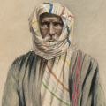
uchi Posted August 29, 2013 lol "The true Somali is an extremely lazy person, for his dignity does not permit him to do manual work; he generally employs himself in watching his flocks, or he will lie for hours under a shady tree, his praying-mat and water-bottle beside him, while he drones, to a sort of chant, songs about his former fights and about the stock he has looted. The manual work, meanwhile, is left to the women and the dependants. The Somali is a Mussulman of the Shujai sect and is very religious in his own fashion. In appearance the Somali is an Arab, and sometimes a hand-some Arab. Treat him with confidence and consideration, he is cheerful, intelligent, willing to learn, and true to his code of honesty. Treat him harshly or unjustly, he becomes sulky, obstinate, mutinous, and dangerous. He is an excellent scout, a wonderful marcher, and very proud if confidence is shown in him. It would be fatal to the peace of the country if the Somali should be treated with that contempt which is often shown to the black races by Europeans." Quote Share this post Link to post Share on other sites
Carafaat Posted August 30, 2013 Of the tribes in Jubaland the Somali are by far the most important. In the whole of East Africa there are two branches of the Somali, the Darud [******] and the Ishaak. The former only is represented in Jubaland. The Dirr and Haweyeh tribes, largely represented in Italian territory and slightly in Jubaland, though called Somali are really the aborigines of the Benidir coast, and are in no way co-tribal with the Somali, with whom they seldom intermarry . The Somali report that about 700 years ago an Arab sheik, Ismail Juberti by name, having been outlawed, fled from his country in a dhow. He landed on the Benidir coast near Hobia (or Obbia), but the Haweyeh, who then lived in the neighbourhood, refused him hospitality, so eventually he joined the Dirr tribe. Quote Share this post Link to post Share on other sites